
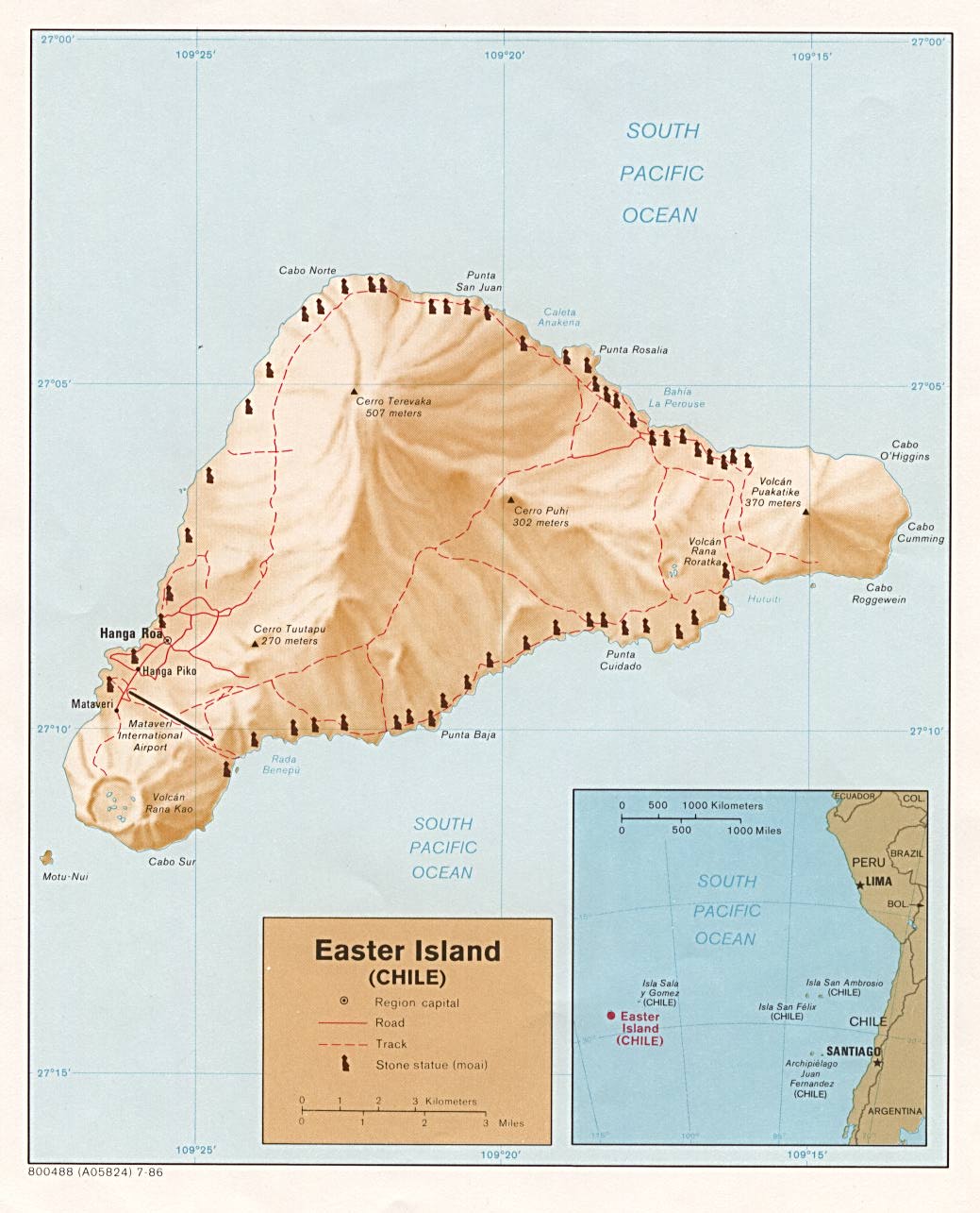
Located in the Pacific Ocean at 27 degrees south of the equator and some 2200 miles (3600 kilometers) off the coast of Chile, Easter Island is considered to be the world's most remote inhabited island.
One of the world's most famous yet least visited archaeological sites, Easter
Island is a small, hilly, now treeless island of volcanic origin. Located in the
Pacific Ocean at 27 degrees south of the equator and some 2200 miles (3600
kilometers) off the coast of Chile, it is considered to be the world's most
remote inhabited island. Sixty-three square miles in size and with three extinct
volcanoes (the tallest rising to 1674 feet), the island is, technically
speaking, a single massive volcano rising over ten thousand feet from the
Pacific Ocean floor. The oldest known traditional name of the island is Te Pito
o Te Henua, meaning ‘The Center (or Navel) of the World.’ In the 1860’s Tahitian
sailors gave the island the name Rapa Nui, meaning ‘Great Rapa,’ due to its
resemblance to another island in Polynesia called Rapa Iti, meaning ‘Little Rapa’.
The island received its most well known current name from the Dutch sea captain
Jacob Roggeveen, who, on Easter Sunday, April 5, 1722, became the first European
to visit.

Photo © by Martin Gray
The Moai statues of Rapa Nui.
In the early 1950s, the Norwegian explorer Thor Heyerdahl (famous for his
Kon-Tiki and Ra raft voyages across the oceans) popularized the idea that the
island had been originally settled by advanced societies of Indians from the
coast of South America. Extensive archaeological, ethnographic, and linguistic
research has conclusively shown this hypothesis to be inaccurate. It is now
recognized that the original inhabitants of Easter Island are of Polynesian
stock (DNA extracts from skeletons have recently confirmed this), that they most
probably came from the Marquesas or Society islands, and that they had arrived
as early as 318 AD (carbon dating of reeds from a grave confirms this). At the
time of their arrival, the island was entirely covered with thick forests, was
teeming with land birds, and was the richest breeding site for seabirds in the
Polynesia region. Within a matter of centuries this profusion of wildlife was
destroyed by the islanders' way of life. The reasons are today eminently clear.
It is estimated that the original colonists, who may have been lost at sea, arrived in only a few canoes and numbered fewer than 100. Because of the plentiful bird, fish and plant food sources, the population grew rapidly and gave rise to a rich religious and artistic culture. However, the resource needs of the growing population inevitably outpaced the island's capacity to renew itself ecologically and the ensuing environmental degradation triggered a social and cultural collapse. Pollen records show that the destruction of the forests was well under way by the year 800, just a few centuries after the start of the first settlement. These forest trees were extremely important to the islanders, being used for fuel, for the construction of houses and ocean-fishing canoes, and as rollers for transporting the great stone statues. By the 1400s the forests had been entirely cut, the rich ground cover had eroded away, the springs had dried up, and the vast flocks of birds coming to roost on the island had long since disappeared. With no logs to build canoes for offshore fishing, with depleted bird and wildlife food sources, and with declining crop yields because of the erosion of good soil, the nutritional intake of the people plummeted. First famine, then cannibalism, set in. Because the island could no longer feed the chiefs, bureaucrats and priests who kept the complex society running, chaos resulted, and by 1700 the population dropped to between one-quarter and one-tenth of its former number. During the mid 1700s rival clans began to topple each other's stone statues. By 1864 the last of the statues was thrown down and desecrated.

Photo © by Martin Gray
The Moai statues, Easter Island
The barren lands and social strife that Admiral Roggeveen reported during his
visit in 1722 make it difficult to imagine the extraordinary culture that had
flowered on the island during the previous 1400 years. That culture's most
famous features are its enormous stone statues called moai, at least 288 of
which once stood upon massive stone platforms called ahu. There are some 250 of
these ahu platforms spaced approximately one half mile apart and creating an
almost unbroken line around the perimeter of the island. Another 600 moai
statues, in various stages of completion, are scattered around the island,
either in quarries or along ancient roads between the quarries and the coastal
areas where the statues were most often erected. Nearly all the moai are carved
from the tough stone of the Rano Raraku volcano. The average statue is 14 feet,
6 inches tall and weighs 14 tons. Some moai were as large as 33 feet and weighed
more than 80 tons (one statue only partially quarried from the bedrock was 65
feet long and would have weighed an estimated 270 tons).

Photos © by Martin Gray
The Moai statues, Easter Island
The moai and ahu were in use as early as AD 700, but the great majority were
carved and erected between AD 1000 and 1650. Depending upon the size of the
statue, between 50 and 150 people were needed to drag it across the countryside
on sleds and rollers made from the island's trees. While many of the statues
were toppled during the clan wars of the 1600 and 1700s, other statues fell over
and cracked while being transported across the island. Recent research has shown
that certain statue sites, particularly the most important ones with great ahu
platforms, were periodically ritually dismantled and reassembled with
ever-larger statues. A small number of the moai were once capped with ‘crowns’
or ‘hats’ of red volcanic stone. The meaning and purpose of these capstones is
not known, but archaeologists have suggested that the moai thus marked were of
pan-island ritual significance or perhaps sacred to a particular clan.Scholars are unable to definitively explain the function and use of the moai statues. It is assumed that their carving and erection derived from an idea rooted in similar practices found elsewhere in Polynesia but which evolved in a unique way on Easter Island. Archaeological and iconographic analysis indicates that the statue cult was based on an ideology of male, lineage-based authority incorporating anthropomorphic symbolism. The statues were thus symbols of authority and power, both religious and political. But they were not only symbols. To the people who erected and used them, they were actual repositories of sacred spirit. Carved stone and wooden objects in ancient Polynesian religions, when properly fashioned and ritually prepared, were believed to be charged by a magical spiritual essence called mana. The ahu platforms of Easter Island were the sanctuaries of the people of Rapa Nui, and the moai statues were the ritually charged sacred objects of those sanctuaries. While the statues have been toppled and re-erected over the centuries, the mana or spiritual presence of Rapa Nui is still strongly present at the ahu sites and atop the sacred volcanoes.
Mystery surrounds the purpose of the ahu platforms and moai statues but even more perplexing mysteries have begun to surface from the research of scholars outside the boundaries of conventional archaeology. As previously mentioned, orthodox archaeologists believe that Easter Island was initially settled sometime around 318 AD by a small group of Polynesians lost on the open sea. Other scholars, however, have suggested that the tiny island may have once been part of far larger island and that the original discovery and use of the site may be many thousands of years earlier in time (it is known, for example, that Melanesians were journeying around the Pacific in boats as early as 5500 BC). Three researchers in particular, Graham Hancock, Colin Wilson and Rand Flem-Ath, believe that Easter Island was an important node in a global grid of sacred geography that predates the great floods of archaic times. Easter Island, writes Graham Hancock, is “part of a massive subterranean escarpment called the East Pacific Rise, which reaches almost to the surface at several points. Twelve thousand years ago, when the great ice caps of the last glaciation were still largely unmelted, and sea-level was 100 meters lower than it is today, the Rise would have formed a chain of steep and narrow antediluvian islands, as long as the Andes mountain range.” At that time, the land we now call Easter Island would simply have been the highest peak of a much larger island. The fascinating question posed by Hancock, Wilson and Flem-Ath is whether this much larger island had been discovered and settled before the melting of the ice caps.
Besides its more well known name of Rapa Nui, Easter Island is also known as Te-Pito-O-Te-Henua, meaning ‘The Navel of the World’, and as Mata-Ki-Te-Rani, meaning ‘Eyes Looking at Heaven’. These ancient names and a host of mythological details ignored by mainstream archaeologists point to the possibility that the remote island may once have been both a geodetic marker and the site of an astronomical observatory of a long forgotten civilization. Speculations about this shadowy antediluvian culture include the notion that its mariners had charted the world’s oceans, that its astronomers had sophisticated knowledge of long-term astronomical cycles such as precession and cometary orbits, and that its historians had records of previous global cataclysms and the destruction they caused of even more ancient civilizations. In his book, Heaven’s Mirror, Hancock suggests that Easter Island may once have been a significant scientific outpost of this antediluvian civilization and that its location had extreme importance in a planet-spanning, mathematically precise grid of sacred sites. He writes, “The very existence of such an ancient world grid has been staunchly resisted by mainstream archaeologists and historians – as, of course, have all attempts to relate known sites to it. Nevertheless, the definite traces of lost astronomical knowledge that are to be seen on Easter Island, and the recurrent echoes of ancient Egyptian spiritual and cosmological themes, cast doubt on the scholarly explanation that the odd name ‘Navel of the World’ was adopted for purely ‘poetic and descriptive’ reasons. We suspect that Te-Pito-O-Te-Henua may originally have been selected for settlement, and given its name, entirely because of its geodetic location.” “What we are suggesting therefore is that Easter Island might have originally have been settled in order to serve as a sort of geodetic beacon, or marker – fulfilling some as yet unguessed at function in an ancient global system of sky-ground co-ordinates that linked many so-called ‘world navels’”.
Two other alternative scholars, Christopher Knight and Robert Lomas, have extensively studied the location and possible function of these geodetic markers. In their fascinating book, Uriel’s Machine, they suggest that one purpose of the geodetic markers was as part of global network of sophisticated astronomical observatories dedicated to predicting and preparing for future meteoric impacts and crustal displacement cataclysms. The great floods of archaic myths did not result only from the melting of the ice caps between 13,000 and 8000 BC but also from two great cataclysms that occurred during and after the melting of the ice caps. These cataclysms, a planet wide crustal displacement in 9600 BC and the seven cometary impacts of 7640 BC resulted in the massive waves (3-5 miles high, traveling at over 400 miles per hour for distances of more than 2000 miles), volcanic activity and other earth changes recorded in myths all across the planet. Prior to the melting of the ice caps and these cataclysmic events, however, a great maritime civilization may have existed, with its cities along coastlines now submerged beneath the seas.
©1983-2005 Martin Gray, ALL RIGHTS RESERVED. Reprinted with permission.
The Article Source: http://www.sacredsites.com/americas/chile/easter_island.html
PLACES OF PEACE AND POWER - The Sacred Site Pilgrimage of Martin Gray
The Article Source: http://www.sacredsites.com/americas/chile/easter_island.html
PLACES OF PEACE AND POWER - The Sacred Site Pilgrimage of Martin Gray


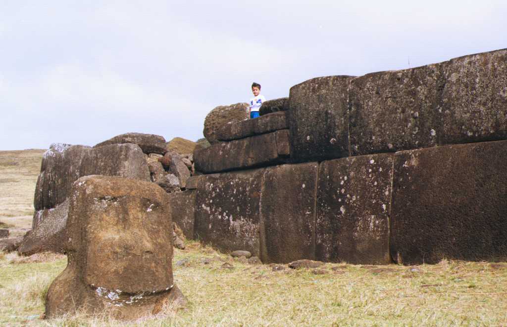
Vinapu: "The sea wall of Ahu Vinapu I at Vinapu,
which has been likened to Inca masonry". Taken in 1995.
Copyright © Clive Ruggles, University of Leicester

Stone wall at Ahu Vinapu, Easter Island


Source: http://www.pbs.org/wgbh/nova/easter/civilization/first.html

Image Source:
Map of Easter Island

Moai Statues, Eastern Island
Photo Credits: Ahu Akivi - Travel Library
She reported, "A total of 887 monolithic statues has been located by the survey to date on Easter Island...397 are still in situ in quarries at the Rano Raraku central production center.....Fully 288 statues (32% of 887) were successfully transported to a variety of image ahu locations....Another 92 are recorded as "in transport," 47 of these lying in various positions on prepared roads or tracks outside the Rano Raraku zone."
Number of Moai
- Total number of moai on Easter Island: 887
- Total number of maoi that were successfully transported to their final ahu locations: 288 (32% of 887)
- Total number of moai still in the Rano Raraku quarry: 397 (45%)
- Total number of moai lying 'in transit' outside of the Rano Raraku quarry:
92 (10%)
Size and weight of Moai
Measuring the size, weight, and shape of the 887 moai on Easter Island has been a 15-year process for Van Tilburg. The most notable statues are listed below:Largest moai:
- Location: Rano Raraku Quarry, named "El Gigante"
- Height: 71.93 feet, (21.60 meters)
- Weight: approximately 145-165 tons (160-182 metric tons)
- Location: Ahu Te Pito Kura, Named "Paro"
- Height: 32.63 feet (9.80 meters)
- Weight: approximately 82 tons (74.39 metric tons)
- Location: Ahu Hanga Te Tenga
- Height: 33.10 feet (9.94 meters)
- Smallest standing moai:
- Location: Poike
- Height: 3.76 feet (1.13 meters)
Statistically average moai:
- Height: 13.29 feet (4.05 meters)
- Width at Base: 5.25 feet (1.6 meters)
- Width at Head: 4.86 feet (1.48 meters)
- Depth through body at midpoint: 3.02 feet (92 cm.)
- Total volume: 210.48 cubic feet (5.96 cubic meters)
- Center of gravity: 4.46 feet (1.36 meters)
- Total weight: 13.78 tons (12.5 metric tons)

Lowering our replica statue face-up onto our A-frame rig modified as
a canoe ladder. ©1998 EISP/JVT/Photo: J. Van Tilburg
Like most oral traditions, Rapa Nui folklore has been passed down through the generations, and it is unknown whether the stories are based on historical fact. Most center on the mystical idea that the massive megaliths were moved using "mana," or divine power. Those who possessed mana were able to command the moai to walk to their designated places. Accounts of who actually possessed mana differ greatly. In 1919, Katherine Routledge, a British archaeologist who lived on Easter Island for a year, recorded in her journal: "There was a certain old woman who lived at the southern corner of the mountain and filled the position of cook to the image-makers. She was the most important person of the establishment, and moved the images by supernatural powers (mana), ordering them about at her will." Earlier accounts recorded by visitors to the island indicate that statues were ordered to walk by the mythical King Tuu Ku Ihu and the god Make Make. Even specialized priests were known to move moai at the request of those who wanted them on their family land or ahu.
Related Links:
- Megaliths and Mariners: Experimental Archaeology on Easter Island
- http://www.pbs.org/wgbh/nova/easter/dispatches/19980430.html
- http://www.pbs.org/wgbh/nova/easter/move/

The Moai statues, Easter Island

Unfinished Statue
Easter Island Slide Collections
- Dr. Ruggles' Easter Island Images (Archaeology slide collection)
- A Japanese Easter Island site (Good quality images)
- Photos by Massimo Casulini
Aucun commentaire:
Enregistrer un commentaire
Remarque : Seul un membre de ce blog est autorisé à enregistrer un commentaire.