From Wikipedia, the free encyclopedia

Often referred to as the "Mona Lisa of the Galilee". Part of a mosaic floor in Sepphoris.
Notable structures at the site include a Roman theater, two early Christian churches, a Crusader fort that was renovated by Daher el-Omar in the 18th century, and over sixty different mosaics dating from the third to the sixth century CE.[3][4]
Following the Bar Kokhba revolt of 132–135, Sepphoris was one of the centers in Galilee where rabbinical families from Judea relocated.[5] Remains of a 6th-century synagogue have been uncovered in the lower section of the site. In the 7th century, the town was conquered by the Arab caliphates like much of the rest of Palestine. Successive Arab and Islamic imperial authorities ruled the area until the end of the first World War I, with a brief interruption during the Crusades.
Until its depopulation during the 1948 Arab-Israeli War,[6] Saffuriya was a Palestinian Arab village. Moshav Tzippori was established adjacent to the site in 1949. It falls under the jurisdiction of Jezreel Valley Regional Council, and in 2006 had a population of 616. The area occupied by the former Arab village was designated a national park in 1992
Contents
History
Early history
Evidence from ceramic remains indicates the site of Sepphoris was inhabited as early as the Iron Age, 1,000-586 BCE. Actual occupation and building work can be verified from the 4th century, with the Hellenistic period.[7] The Bible makes no mention of the city.[8] In 104 BCE, the Judean priestly dynasty of the Hasmoneans conquered Galilee under the leadership of either Alexander Jannaeus or Aristobulus I and at this time the town may have been administered by a quarter-master, probably Jewish, and by the middle of the 1st century BCE, after the campaigns of Pompey, it fell under Roman rule in 63 BCE became one of the five synods of Roman rule in the Syro-Palestinian Middle East. The Roman client king, Herod the Great recaptured the city in 37 BCE after it had been garrisoned by the Parthian proxy, the Hasmonean Antigonus II Mattathias.[9] The city was called Sepphoris from the word tzippori, a variant of the Hebrew word for bird, tsippor, perhaps, as a Talmudic gloss suggests, because it is "perched on the top of a mountain, like a bird".[10][11]
Ancient Galilee
At the time of Jesus, Sepphoris was a large, Roman-influenced city. Reza Aslan describes it at the time of Jesus's growing into maturity one mile away in the following terms:
Rich, cosmopolitan, deeply influenced by Greek culture, and surrounded by a panoply of races and religions, the Jews of Sepphoris were the product of the Herodian social revolution - the nouveaux riches who rose to prominence after Herod's massacre of the old priestly aristocracy.'[15]It has been suggested that Jesus, while living in Nazareth, may have worked as a craftsman at Sepphoris,[16] where, during his youth 'the largest restoration project' of his time took place.[17]Archaeological investigations at the site have led to numerous debates about the influence of this town on Jesus, and shed light on differences within Galilean society.
The inhabitants of Sepphoris did not join the Great Jewish Revolt against Roman rule of 66 CE. The Roman legate in Syria, Cestius Gallus, killed some 2,000 "brigands and rebels" in the area, and sold its inhabitants into slavery.[18] The Jerusalemite Josephus, a son of Jerusalem's priestly elite had been sent north to recruit the Galilee into the rebellion's fold, but was only partially successful. He made two attempts to capture Sepphoris, but failed to conquer it, the first time because of fierce Galilean resistance, the second because a garrison came to assist in the city's defence.[19] Around the time of the rebellion Sepphoris had a Roman theater - in later periods, bath-houses and mosaic floors depicting human figures. Sepphoris and Jerusalem may be seen to symbolize a cultural divide between those that sought to avoid any contact with the surrounding Roman culture and those who within limits, were prepared to adopt aspects of that culture. Rejected by Sepphoris and forced to camp outside the city Josephus went on to Jotapata, which did seem interested in the rebellion, - the siege of Jotapata ended on July 20 67 A.D. Towns and villages that did not rebel were spared and in Galilee they were the majority.[20] Coins minted in the city at the time of the Great Revolt carried the inscription Neronias and Eirenopolis, "City of Peace". After the revolt, symbolism used on the coins was little different from other surrounding pagan city coins with depictions of laurel wreaths, palm trees, caduceuses, and ears of barley.[citation needed]
Just prior to the Bar Kokhba revolt, the city's name was changed to Diocaesarea in Hadrian's time, in honor of Zeus and the Roman emperor. Following the revolt in 132–135, many Jewish refugees from devastated Judea settled there, turning it into a center of Jewish religious and spiritual life.[citation needed] Rabbi Yehuda Hanasi, one of the compilers of the Mishnah, a commentary on the Torah, moved to Sepphoris, along with the Sanhedrin, the highest Jewish religious court.[21] Before moving to Tiberias by 150, some Jewish academies of learning, yeshivot, were also based there. The Galilee was predominantly populated by Jews from the end of th 2nd century to the 4th century CE.[22]The idea that Sepphoris was under a "priestly oligarchy" by the third century, is unconvincing, and may reflect a misreading of Talmudic sources.[23] Aside from being a center of spiritual and religious studies, it developed into a busy metropolis for commerce due to its proximity to important trade routes through Galilee. Hellenistic and Jewish influences seemed blended together in daily town life while each group, Jewish, pagan and Christian, maintained its distinct identity.[24]
Diocaesarea was destroyed by the Galilee earthquake of 363, but rebuilt soon afterwards, and retained its importance in the greater Jewish community of the Galilee, both socially, commercially, and spiritually.[citation needed]
The town was also the centre of a Christian bishopric. Three of its early bishops are known by name: Dorotheus (mentioned in 451), Marcellinus (mentioned in 518), and Cyriacus (mentioned in 536).[25][26][27] As a diocese that is no longer residential, it is listed in the Annuario Pontificio among titular sees.[28][29]
Islamic conquest and the Crusaders
Ya'qubi noted that Saffuriyyah was taken during the first conquest by the Arab armies in Palestine,[30] in 634.[31] The city was incorporated into the expanding Umayyad Caliphate, and al-jund coins were minted by the new rulers.[32] Saffuriya was engaged in trade with other parts of the empire at the time; for example, cloaks made in Saffuriyya were worn by people in Medina.[33] Umayyad rule was replaced by Abbasid rule, and Arab and Islamic dynasties continued to control the city, with a brief interlude during the Crusades, up until World War I. Throughout this period of time, the city was known by the Semitic name Saffuriya.[34] After this, the region was controlled by the British who ruled over the British Mandate until the creation of the State of Israel in 1948.The early 12th century brought the Crusaders to Palestine. They built a fort and watchtower atop the hill, overlooking Saffuriya, and dedicated it to Anne and Joachim, the putative parents of the Virgin Mary.[8] This became one of their local bases in the Kingdom of Jerusalem and they renamed the city La Sephorie. In 1187, the Crusaders were dispatched from La Sephorie to fight the Battle of Hattin. After the defeat of the Crusaders by Saladin, the Ayyubid Sultan renamed the city Saffuriya. In the 15th century, Saffuriya came under the control of the Ottomans. It remained a titular see of the Catholic Church under the name Diocaesarea in Palaestina.
In the fourteen centuries between the rule of Herod of Antipas and that of the Ottoman Empire, the city reportedly thrived as a center of learning, with a diverse, multiethnic and mutlireligious population of some 30,000 living in relatively peaceful coexistence.[35]
Modern history
| Saffuriyya | |
|---|---|

Sefurieh, 1859
|
|

Saffuriyya
|
|
| Arabic | صفورية |
| Also spelled | Suffurriye, Safurriya |
| Subdistrict | Nazareth |
| Coordinates | 32°45′10.4″N 35°16′46.2″ECoordinates: 32°45′10.4″N 35°16′46.2″E |
| Palestine grid | 176/239 |
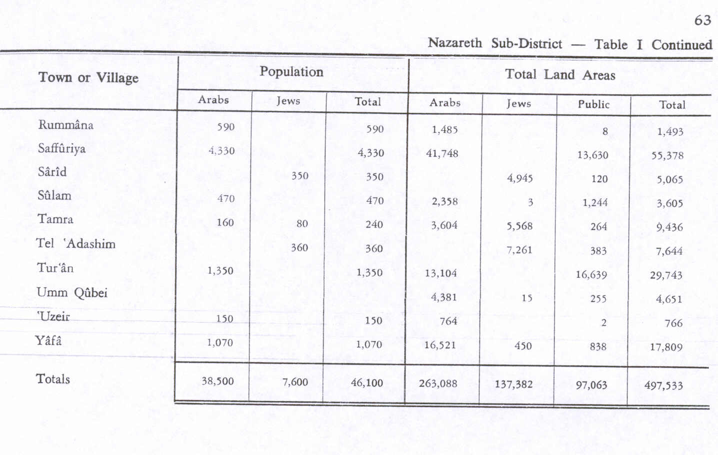
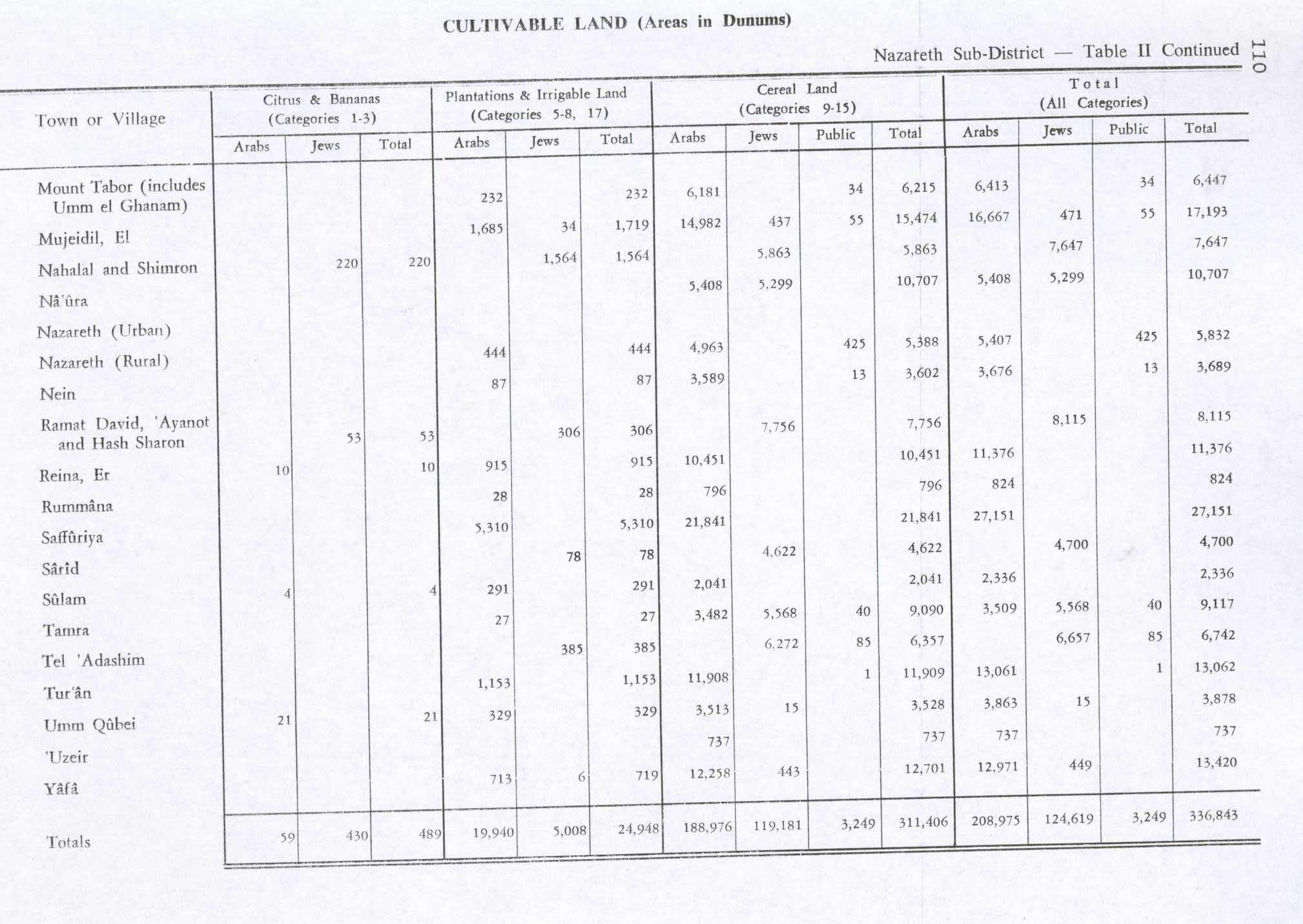
| Population | 4,330[36] (1945) |
| Area | 55,378[36] dunams |
| Date of depopulation | 16 July 1948/January 1949[37] |
| Cause(s) of depopulation | Military assault by Yishuv forces |
| Secondary cause | Expulsion by Yishuv forces |
| Current localities | Tzippori and the village land was distributed between Kibbutz Sde Nahum, Kibbutz Heftziba and Kibbutz HaSolelim[37][38] |


Crusader/Ottoman Fort, the upper part was used as a school from the early 1900s (decade) until 1948.[39] Note doorway constructed under Daher el-Omar.
It is reported that in 1745 Daher el-Omar, who grew up in the town,[43] built a fort on the hilltop above Saffuriya.[31]
A map from Napoleon's invasion of 1799 by Pierre Jacotin showed the place, named as Safoureh.[44]
In the early 19th century, the British traveller J. Buckingham noted that all the inhabitants of Saffuriya were Muslim, and that the house of St. Anna had been completely demolished.[31][45]
In the late 19th century, Saffuriyya was described as village built of stone and mud, situated along the slope of a hill. The village contained the remains of the Church of St. Anna and a square tower, said to have been built in the mid-18th century. The village had an estimated 2,500 residents, who cultivated 150 faddans (1 faddan = 100-250 dunams), on some of this land they had planted olive trees.[46] In 1900, an elementary school for boys was founded, and later, a school for girls. A local council was established in 1923. The expenditure of the council grew from 74 Palestinian pounds in 1929 to 1,217 in 1944.[31]
Though it lost its centrality and importance as a cultural center under the Ottomans (1517–1918) and the British Mandate (1918–1948), the village thrived agriculturally. Saffuriyya's pomegranates, olives and wheat were famous throughout the Galilee.[47]
In summer of 1931, archaeologist Leroy Waterman began the first excavations at Saffuriya, digging up part of the school playground, formerly the site of the Crusader fort.[1]
In 1944/45 a total of 21,841 dunams of village land was used for cereals, 5,310 dunams were irrigated or used for orchards, mostly olive trees.[31][48] By 1948, Saffuriya was the largest village in the Galilee both by land size and population, which was estimated at 4,000 Arabs.[49]
On 1 July 1948, during the 1948 Arab–Israeli War, the village was bombarded by Israeli aircraft.[49] On 16 July it was captured by Israeli forces along with the rest of the lower Galilee in Operation Dekel. The villagers put up some resistance and managed to destroy several armoured cars in an ambush.[50] Following the collapse of the resistance all but 80 of the villagers fled. Some made their way northwards toward Lebanon, finally settling in the refugee camps of Ain al-Hilweh and Shatila and the adjacent Sabra neighborhood in Lebanon. Others fled south to Nazareth and the surrounding countryside. After the attack, the villagers returned but were evicted again in September 1948.[6] On 7 January 1949, 14 residents were deported and the remaining 550 were resettled in neighboring Arab villages such as 'Illut.[6] Many settled in Nazareth in a quarter now known as the al-Safafira quarter because of the large number of Saffuriyya natives living there.[47] As the Israeli government considers them absentees, they cannot go back to their old homes and have no legal recourse to recover them.[51]
The area remained under martial law until 1966.
The site of the Arab village was planted with pine trees.[49] On February 20, 1949, the Israeli moshav of Tzippori was founded southeast of the former village.[49] The pomegranate and olive trees were replaced with crops for cattle fodder.[52] Most of the remains of Saffuriya were removed in a late-1960s program to clear abandoned Arab villages.[53]
Archaeological sites in the national park
The history of Sepphoris as presented in the modern day national park mainly covers the periods up to Roman and Byzantine rule, with mention of the Crusades, the period of rule under the Arab caliphates and the Ottoman Empire and British rule.The Crusader/Ottoman tower sits high atop the hill, overlooking both the Roman theater, the majority of the Jewish city and the destroyed Palestinian village. It was built in the 12th century, on the foundation of an earlier Byzantine structure. The tower is built as a large square, 15m x15m, and approximately 10 m. high. The lower part of the walls are built of reused antique spolia, including a sarcophagus with decorative carvings. The upper part of the tower and the doorway were constructed by Daher el-Omar in the 18th century. Noticeable features from the rebuilding are the rounded corners which are similar to those constructed under Daher in the fort in Shefa-'Amr. The upper part of the building was converted for use as a school during the reign of Abdul Hamid II in the early 1900s (decade), and used for this purpose until 1948.[54]
Much of the town itself has been excavated, revealing Jewish homes along a main cobblestone street. Several images have been found carved into the stones of the street, including that of a menorah, and another image that resembles some ancient game reminiscent of tic-tac-toe. Mikva'ot, Jewish ritual baths, have been found as well, identified by the steps leading to the bottom, carved out of the earth along with the rest of the bath.[55] The Roman theater sits on the northern slope of the hill, and is about 45 m in diameter, seating 4500. Most of it is carved into the hillside, but some parts are supported by separate stone pillars. The theater shows evidence of ancient damage, probably from the earthquake in 363, but also quite possibly from the Arab conquest.[citation needed]

Offering of fruits and grains, the Nile House Mosaic
Finally, a Roman villa is arguably the centerpiece of the discoveries, containing one of the most famous mosaics in Israel. It was built around the year 200 and destroyed in the earthquake of 363. The villa is in the traditional form of a triclinium; seats would have been arranged in a U-shape around the mosaic, Roman villa mosaic floor and people would have reclined while dining and drinking, talking and contemplating the mosaic images. The mosaic, for the most part, is devoted to Dionysus, god of wine, and of socializing. He is seen along with Pan and Hercules in several of the 15 panels.[56]

Dionysus Party
Synagogue

Zodiac Wheel Mosaic in the great synagogue of Tzippori, 5th century
The mosaic floor is divided into seven parts. Near the entrance there is a scene showing the angels visiting Sarah. The next section shows the binding of Isaac. There is a large Zodiac with the names of the months written in Hebrew. Helios sits in the middle, in his sun chariot. The last section shows two lions flanking a wreath, their paws resting on the head of an ox.
The most interesting are the central sections of the mosaic. One shows the "tamid" sacrifice, the showbread, and the basket of first fruits form the Temple in Jerusalem. Also shown are a building facade, probably representing the Temple, incense shovels, shofars, and the seven-branched menorah from the Temple. Another section shows Aaron dressed in priestly robes preparing to offer sacrifices of oil, flour, a bull and a lamb.
An Aramaic inscription reads: "May he be remembered for good Yudan son of Isaac the Priest and Paragri his daughter Amen Amen"[57]
In popular culture
Sepphoris was one of the cornerstones in "Exile - A Myth Unearthed" documentary.[clarification needed] The documentary was trying to answer whether Jewish exile is a truth or a myth.[58][59][clarification needed]See also
References
- BBC Searching for Exile Searching for Exile Truth or Myth https://www.youtube.com/watch?v=Ozbt9bfLiYA
Bibliography
- Batey, Richard A. (1991): Jesus and the Forgotten City: New Light on Sepphoris and the Urban World of Jesus, Grand Rapids, Mich.: Baker Book House.
- Barron, J. B., ed. (1923). Palestine: Report and General Abstracts of the Census of 1922 (PDF). Government of Palestine.
- Benveniśtî, Mêrôn (2002). Sacred landscape: the buried history of the Holy Land since 1948 (Illustrated ed.). University of California Press. ISBN 9780520234222.
- Buckingham, James Silk (1821): Travels in Palestine Through the Countries of Bashan and Gilead, East of the River Jordan, Including a Visit to the Cities of Geraza and Gamala in the Decapolis
- Chancey, Mark A. (2005). Greco-Roman culture and the Galilee of Jesus (Illustrated ed.). Cambridge University Press. ISBN 9780521846479.
- Crone, Patricia (2004). Meccan trade and the rise of Islam. Gorgias Press. ISBN 9781593331023.
- (IIED), International Institute for Environment & Development (1994). Evictions - 7010iied. IIED. ISBN 9781843690825.
- Hadawi, Sami (1970). Village Statistics of 1945: A Classification of Land and Area ownership in Palestine. Palestine Liberation Organization Research Center.
- Heyd, Uriel (1960): Ottoman Documents on Palestine, 1552-1615, Oxford University Press, Oxford. Cited in Petersen (2002)
- Horsley, Richard A. (1996): Archaeology, History and Society in Galilee: The Social Context of Jesus and the Rabbis, Valley Forge, PA: Trinity Press International.
- Hütteroth, Wolf-Dieter; Abdulfattah, Kamal (1977). Historical Geography of Palestine, Transjordan and Southern Syria in the Late 16th Century. Erlanger Geographische Arbeiten, Sonderband 5. Erlangen, Germany: Vorstand der Fränkischen Geographischen Gesellschaft. ISBN 3-920405-41-2.
- Kacowicz, Arie Marcelo; Lutomski, Pawel (2007). Population resettlement in international conflicts: a comparative study (Illustrated ed.). Lexington Books. ISBN 9780739116074.
- Karmon, Y. (1960). "An Analysis of Jacotin's Map of Palestine" (PDF). Israel Exploration Journal 10 (3,4): 155–173; 244–253.
- Khalidi, Walid (1992). All That Remains: The Palestinian Villages Occupied and Depopulated by Israel in 1948. Washington, D.C.: Institute for Palestine Studies. ISBN 0-88728-224-5.
- le Strange, Guy (1890). Palestine Under the Moslems: A Description of Syria and the Holy Land from A.D. 650 to 1500. Committee of the Palestine Exploration Fund.
- Mills, E., ed. (1932). Census of Palestine 1931. Population of Villages, Towns and Administrative Areas (PDF). Jerusalem: Government of Palestine.
- Morris, Benny (2004). The Birth of the Palestinian Refugee Problem Revisited. Cambridge University Press. ISBN 978-0-521-00967-6.
- Petersen, Andrew (2001). A Gazetteer of Buildings in Muslim Palestine (British Academy Monographs in Archaeology) 1. Oxford University Press. ISBN 978-0-19-727011-0.
- Reed, Jonathan (2002): Archaeology and the Galilean Jesus: A Re-Examination of the Evidence, Harrisburg, PA, Trinity Press International.
- Richardson, Peter (1996). Herod: king of the Jews and friend of the Romans (Illustrated ed.). University of South Carolina Press. ISBN 9781570031366.
- Rowan, Yorke M.; Baram, Uzi (2004). Marketing heritage: archaeology and the consumption of the past (Illustrated ed.). Rowman Altamira. ISBN 9780759103429.
External links
| Wikimedia Commons has media related to Tzippori. |
| Wikivoyage has a travel guide for Zippori. |
- Tzippori excavation project Hebrew University of Jerusalem
- Saffuriyya Palestine Remembered
- Survey of Western Palestine, Map 5: IAA, Wikimedia commons
- Saffuryeh, from Dr. Moslih Kanaaneh
- Zippori Hillel International
- Zippori Israel Ministry of Foreign Affairs. (Accessed 9 February 2005)
- "The Surprises of Sepphoris" PBS Frontline
Aucun commentaire:
Enregistrer un commentaire
Remarque : Seul un membre de ce blog est autorisé à enregistrer un commentaire.